Answering your saltmarsh questions
Responding to questions we've had so far about our plans for saltmarsh restoration on the Awre peninsula.

We announced our plans to carry out a saltmarsh restoration project on the Awre peninsula on Tuesday 10 December and have been encouraged by the positive response so far.
The project will see landscape-scale change to the Awre peninsula, bringing multiple benefits to the local area, people and wildlife. We’ve received a number of questions about what this change might look like, and how the work we plan to do could impact other parts of the Severn Estuary.
Let’s take a look at some of those questions.
Will saltmarsh form so far up the estuary?
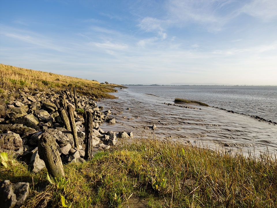
Yes, and there are a few reasons we’re sure of this. There is already a large area of saltmarsh just across the river from Awre, at WWT Slimbridge. This saltmarsh type, known as Atlantic salt pasture, is an internationally important wetland habitat that supports an incredible array of wildlife, including large numbers of European white-fronted geese over winter.
Based on the elevation of the land we’ve purchased at Awre, we expect it to support a range of saltmarsh plants, from species that can survive frequent flooding with saltwater through to the grassy species that grow on higher areas of saltmarshes. This mix will change over time as sediment builds up and parts of the marsh are grazed, but all of them are valuable to different species and will significantly increase the biodiversity of the restored habitat.
We’ve also done our due diligence, measuring salinity, examining local history and looking for the kinds of plants we would want to see on the site. During a recent visit to Awre, we found colonies of a range of saltmarsh plants on the sediment in front of the defences and even directly in cracks in the sea wall. These plants are growing at sediment levels higher than much of the Awre peninsula.
What modelling are you doing to understand how your project at Awre will affect the flow of water in the wider estuary?
We’re working with expert consultants Jacobs, who are carrying out detailed predictions of how water will move across the site and through the estuary, known as hydrodynamic modelling, as part of the design process. Their early modelling work, which is informing design development, confirms that:
- the impact on tidal currents in the wider estuary from the breach will be negligible (less than 0.05 m/s on average);
- a breach will not have a significant effect on the extreme water levels in the wider estuary.
Jacobs use industry standard models, the kind used by the Environment Agency, so we have full confidence in them. It’s worth remembering that modelling confirms that the establishment of saltmarsh is possible and informs the process of designing a site but is only one aspect of what informs a final decision.
Will habitat restoration at Awre affect the Severn bore?
Our early modelling shows that the bore will still run as normal, because the wave will pass the entrance to the breach before the site begins to fill with water, but more detailed investigation into this is planned as the full design takes shape.
Is this saltmarsh restoration or creation?
This project is about saltmarsh restoration. Loss of saltmarsh in the wider estuary is estimated to be around 85% to 90% and there are relatively few areas of saltmarsh left on the estuary today.
After carrying out historical and scientific research in the area, we’ve found evidence demonstrating that saltmarsh was once present on the Awre peninsula. People have tried to keep water out of the area for hundreds of years, and there’s evidence of old flood embankments at the site. The land we’ve agreed to purchase is all below the highest astronomical tide, making it prone to tidal flooding, which is a basic condition for the formation of saltmarsh. Much of the land is also below the Mean High Water Spring tides (MHWS), which is an annual average of high water levels. The highest visible line of seaweed, driftwood and other marine debris that gathers on a shoreline over a year is generally a good indicator of MHWS.
It’s also important to note that the current salinity levels in the estuary at Awre, and the presence of saltmarsh-tolerant plants growing in the peninsula’s sea wall, show that the area would eventually return to saltmarsh on its own.
Are you just destroying one habitat for another?
The land we’ve purchased is mostly improved grassland – a land type that has often been ploughed, reseeded or fertilised and has a low diversity of species. There are some managed hedgerows, some mature trees and a large area of arable land for a maize crop. We know that there are some species that will be using the existing hedges and mature trees to feed and nest, and we plan to plant new hedges at the upper end of the reserve to make up for those lost on the marsh.
As well as significantly increasing the area of saltmarsh to attract a huge variety of wildlife to the peninsula, we will also consider creating scrapes and saline lagoons, improving ditches and sowing wildflowers on the new flood bank. We’re very interested to hear from the local community about how to make the site attractive for the widest possible mix of wildlife.
Are you flooding productive farmland to create homes for wildlife?
Landscape-scale change within a rural community, especially one built on farming, will be felt more acutely and we understand the immediate concerns about the loss of farmland. The land we’ve purchased at Awre is very low-lying and at increasingly high risk of flooding. The land has flooded recently, and farmers are painfully aware of the danger to grazing animals when major flooding events do take place.
While grazing will have to pause on the land during construction, we plan to work with local farmers to reintroduce grazing livestock on as much as the saltmarsh as possible, to allow those opportunities for food production. We do the same at WWT Steart Marshes.
Left alone, an accidental breach of the defences would result in no recompense for landowners, the potential loss of all access to the site, unmanaged and unmitigated loss of trees and shrubs, and potentially dangerous erosion.
Will you do archaeological investigations on site?
It’s highly likely we will have to do some archaeological work to determine whether, and what parts of, the site are of historical significance. Ridge and furrow farming has been present on the land for some time and these features are visible on Lidar maps. If areas of archaeological significance are found we will make sure these are properly recorded, and we will avoid creating creeks too nearby and allow silt to cover it to preserve them. Where feasible, we will not disturb these areas with construction equipment.
What about the footpath around the top of the flood embankment?
We realise the footpath around the edge of the Awre peninsula is highly valued locally and we will be working with Gloucestershire County Council on our application to provide a good alternative. The current footpath is under threat if the bank fails and is difficult to walk in places. We will provide an alternative route with a better surface which follows the tow of the hillside and provides views across the site to the estuary.
When will detailed designs be available?
We are still working on the detailed designs. We have done the initial feasibility, baseline and design work to understand the lay of the land and water, land ownership and other factors that could impact our plans. We continue to collect baseline information on the site (such as the species that already use the land), consulting with the community and statutory authorities, and are using this information to inform our plans.
Details about construction and when the site will be accessible to the community are still some way off, but we know these are really important. We’re very excited about showing designs to the community, but we also don’t want to present plans too early. Once we’re confident that our designs are ready to share, we’ll take feedback and seek to improve them further with valuable local knowledge.
As this project progresses, we’ll continue to provide answers to as many of your questions as we can. If you have any concerns or questions about the impact the project might have on you or someone you know in the community, please email us at saltmarshsolutions@wwt.org.uk.


